
Auburn's Proposed 2026 Zoning Map Changes: How to Check Your Property
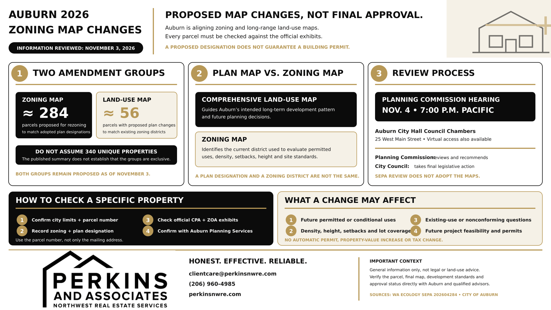
Auburn is proposing zoning map changes affecting approximately 284 parcels, along with separate Comprehensive Land Use Map amendments affecting approximately 56 parcels.
The proposals address inconsistencies between the city's zoning map and its long-range land-use map following Auburn's 2024 Comprehensive Plan update.
For property owners, the important question is whether a specific parcel is included and what its proposed designation would mean.
A zoning change can affect which uses and development standards apply to a property. But the answer depends on the parcel's existing zoning, proposed zoning, and other applicable regulations.
These changes have not received final City Council approval.
Auburn's Planning Commission has scheduled a public hearing for November 4, 2026. The amendments must proceed through the city's review process before they can be treated as adopted.
If you own property in Auburn, are considering buying a home, or are evaluating land for future development, here's how to understand the proposal and check your property.
Key takeaways
- Approximately 284 parcels are proposed for zoning changes. These changes would align zoning districts with land-use designations already adopted in Auburn's Comprehensive Plan.
- Approximately 56 parcels are included in separate land-use map amendments. Those changes would align Comprehensive Plan designations with existing zoning districts.
- The two categories are different. The published summary does not establish that they represent 340 unique properties.
- The amendments are not yet adopted. The Planning Commission hearing is scheduled for November 4, 2026.
- Not every property will gain additional development rights. The effect depends on its specific existing and proposed designations.
- Existing buildings are not automatically required to change. Questions about lawful existing uses and nonconforming status require property-specific review.
- Property owners can review official amendment exhibits. Auburn's current mapping tools and the state's SEPA Register are the starting points.
- A proposed zoning designation does not guarantee a construction permit or an increase in property value.
What zoning map changes is Auburn proposing in 2026?
Auburn's 2026 Annual Map Amendments are intended to correct differences between the city's Comprehensive Land Use Map and its zoning map.
According to the Washington Department of Ecology's official SEPA record, the proposal contains two groups of changes.
Proposed amendment | Approximate parcels | Intended result |
|---|---|---|
Zoning map amendments | 284 | Change zoning districts to implement adopted Comprehensive Plan land-use designations |
Comprehensive Land Use Map amendments | 56 | Change plan designations to match existing zoning districts |
Both categories are part of the 2026 annual amendment process.
They address inconsistencies identified after Auburn completed its major Comprehensive Plan update in December 2024.
Why is Auburn proposing to rezone approximately 284 parcels?
For this group, the city proposes changing zoning districts so they align with land-use designations already established in the adopted Comprehensive Plan.
A Comprehensive Plan establishes the community's long-term land-use direction.
Zoning provides more specific rules governing the uses and development standards applicable to individual properties.
When the two maps do not align, a property may have an adopted land-use designation that points toward one type of development while its existing zoning district provides different regulations.
The proposed rezones are intended to resolve those inconsistencies.
For a parcel in this category, the proposed change could affect the zoning rules used to evaluate a future development application.
However, the precise effect cannot be determined without comparing that parcel's existing district with its proposed district.
What about the approximately 56 land-use map changes?
The second group works in the opposite direction.
Rather than changing zoning to match the Comprehensive Plan, Auburn proposes changing the Comprehensive Land Use Map designation to match an existing zoning district.
That distinction is important.
A change to a long-range land-use designation is not necessarily the same as changing the parcel's current zoning rules.
Property owners should identify which category applies before making assumptions about permitted uses.
Why did these inconsistencies occur?
Auburn adopted its most recent major Comprehensive Plan update on December 16, 2024, through Ordinance 6960.
Comprehensive planning involves reviewing future housing, employment, infrastructure, transportation, and land-use needs.
The city's Comprehensive Planning page explains the 2024 update and the annual process for considering additional amendments.
Auburn's current proposal is intended to bring the affected maps into better alignment with the land-use framework adopted during that update.
It should not be confused with a citywide decision to replace every property's zoning.
What is the difference between zoning and a Comprehensive Plan land-use designation?
A Comprehensive Plan land-use designation describes a city's intended long-term development pattern. Zoning establishes more specific rules governing how a property may currently be used and developed.
Both are important, but they serve different purposes.
Comprehensive Land Use Map | Zoning map |
|---|---|
Guides long-term planning | Establishes specific zoning districts |
Identifies intended land-use patterns | Helps determine permitted and conditional uses |
Supports planning for growth and infrastructure | Applies development standards such as setbacks, height, and density |
Guides future zoning decisions | Used in evaluating development applications |
May identify broader land-use categories | Identifies the district regulations applicable to a property |
A simple example
Imagine a property with a Comprehensive Plan designation intended to support mixed-use development, while its current zoning permits a narrower set of commercial uses.
A city may propose updating the zoning to better implement the adopted land-use designation.
Alternatively, the city may determine that the existing zoning should remain in place and update the plan designation to match.
These are illustrative situations, not verified examples of specific parcels in Auburn's 2026 proposal.
The difference matters because a land-use map correction and a zoning district change can have different consequences.
For a real Auburn property, the correct approach is to compare the official maps and proposed amendment exhibits.
How can I check whether my Auburn property is included?
The most reliable way to check whether a property is included is to identify its parcel number, verify its current zoning and Comprehensive Plan designation, and compare those records with Auburn's official 2026 amendment exhibits.
A mailing address alone is not enough to determine whether a property is subject to the proposal.
Step 1: Confirm the property is inside Auburn city limits
Start with Auburn's City Limit Tool.
This helps determine whether the property falls within incorporated Auburn.
Some properties have Auburn mailing addresses but are not within Auburn's municipal jurisdiction.
Those properties may be subject to different land-use authorities.
Auburn also includes areas in both King County and Pierce County.
The city's proposed map amendments should not be described as limited entirely to King County without checking the relevant parcels.
Step 2: Find the parcel number
A parcel number helps identify the exact property and reduces confusion when nearby parcels have similar addresses.
For properties in King County, use the county's parcel mapping resources.
For properties in Pierce County, use Pierce County's property and mapping resources.
Auburn's Community Development FAQ provides links to both county parcel systems.
Keep the parcel number available for the next steps and any communication with city staff.
Step 3: Check the current zoning designation
Use Auburn's official public zoning map.
Locate the property and activate the zoning layer.
Record the current zoning designation shown for the parcel.
Auburn's mapping system includes different residential, commercial, industrial, and special-purpose zoning districts.
Do not assume that the name of a district alone tells you every permitted use.
Specific zoning standards must be checked in Auburn City Code.
Step 4: Find the current Comprehensive Plan designation
Next, review the property's adopted land-use designation.
Auburn provides land-use and planning map information through its GIS mapping resources and Comprehensive Planning page.
Record the designation separately from the zoning district.
If the two labels differ, that alone does not establish that the parcel is one of the proposed amendments.
The official amendment exhibits must still be checked.
Step 5: Review the 2026 amendment exhibits
Open the official SEPA record for the 2026 Annual Map Amendments.
The record includes these attachments:
- SEP26-0017 CPA Map Amendments 1-5
- SEP26-0017 CPA Map Amendments 6-10
- SEP26-0017 ZOA Map Amendments
The CPA documents concern Comprehensive Plan map changes.
The ZOA document concerns the proposed zoning map amendments.
Find the relevant property in the exhibits and compare the current and proposed designations.
The exhibits are large PDF files, so readers may find it easier to review them on a desktop or request help from Auburn Planning Services.
Step 6: Confirm the proposed change with Auburn Planning Services
If you believe your parcel is included, contact the city with its parcel number and the applicable amendment exhibit.
Ask staff to confirm:
- Whether the parcel is part of CPA26-0004.
- Which amendment category applies.
- The current zoning designation.
- The proposed zoning or land-use designation.
- The development standards that could change.
- Whether any existing permits or lawful uses need additional consideration.
- The current status of the proposal.
Auburn Planning Services
Email: [email protected]
Phone: 253-931-3003
These questions are especially important before buying property based on a proposed zoning change.
What could a zoning change mean for an Auburn property owner?
A zoning change may affect the rules that apply to future uses or development of a property, but it does not necessarily require changes to an existing building.
The effect depends on the current and proposed districts and the property's individual circumstances.
Permitted uses
Different zoning districts allow different uses.
A change could affect whether a particular residential, commercial, mixed-use, or other activity is permitted, conditionally allowed, or prohibited.
However, Auburn's 2026 proposal does not establish that every affected property will gain more permitted uses.
Some changes may narrow or simply clarify the applicable zoning.
Residential density and additional housing
Zoning can influence the number and type of housing units that may be permitted.
For example, development standards may address lot size, density, building form, and the conditions for creating additional housing.
An owner considering another residence, an accessory dwelling unit, or a subdivision should not rely on the proposed zoning label alone.
Auburn's Title 18 zoning regulations provide the applicable district and development standards.
State housing laws may also affect certain uses, so the final answer requires reviewing both state and local requirements.
Building size and setbacks
A zoning district can affect building height, setbacks, lot coverage, and other site-design requirements.
Those standards may influence whether a proposed addition or new development is practical.
Even when zoning allows a use, site conditions, utilities, access, environmental requirements, and building permits can still affect the project.
Commercial or business use
For commercial property owners, a zoning designation may affect the types of businesses that can operate at a location.
However, the proposed map changes should not be confused with Auburn's separate 2026 zoning-text updates.
For example, our article on Auburn's proposed live/work zoning rules addresses standards for combining residential and business functions in qualifying units.
That is a different regulatory issue from the 2026 annual map amendments.
Could existing Auburn homes or businesses become nonconforming?
A zoning amendment can raise questions about existing lawful uses, but it does not automatically mean that a building must close, be demolished, or be altered.
When a lawful use existed before a zoning change and does not meet the new district's requirements, it may be treated as a nonconforming use or structure under applicable law.
The details matter.
Auburn has specific provisions addressing nonconforming structures, land, and uses in Chapter 18.54 of the Auburn City Code.
Those rules should be reviewed with the property's permit history and proposed designation.
Questions owners should ask
If your property is included, ask Auburn Planning Services whether:
- Your existing use remains permitted.
- The property could become legally nonconforming.
- Existing permits or approvals are affected.
- Future renovations or expansions would face additional restrictions.
- A change of use would require new approvals.
- A future sale would affect the rights associated with the existing use.
These questions are more useful than assuming that a proposed rezone makes an existing property unlawful.
Does Auburn's SEPA environmental review mean the map changes are approved?
No. Auburn's environmental review does not, by itself, adopt the proposed zoning or Comprehensive Plan map amendments.
The city issued a SEPA addendum addressing the proposed 2026 Annual Map Amendments.
SEPA stands for the State Environmental Policy Act.
It requires environmental review for qualifying government actions and development proposals.
Auburn's addendum builds on the environmental impact statement prepared for the 2024 Comprehensive Plan update.
The city concluded that the proposed map corrections would not produce new or substantially different environmental impacts beyond those previously evaluated.
The final environmental impact statement associated with the 2024 update was issued October 18, 2024.
What does that mean for the proposal?
The environmental determination explains how the city is addressing SEPA requirements for the map amendments.
It is not a substitute for the Planning Commission process or final City Council adoption.
Auburn must still complete the applicable legislative review.
Future development proposals may also require permits and other reviews depending on the specific project.
Environmental review, zoning adoption, and project approval are separate decisions.
When will Auburn decide on the proposed 2026 zoning map changes?
Auburn's Planning Commission has scheduled a public hearing on November 4, 2026, at 7 p.m. Pacific Time.
The meeting is scheduled to take place at:
Auburn City Hall Council Chambers
25 West Main Street
Auburn, WA 98001
The city also provides virtual meeting access through its public meeting process.
The proposed amendment is identified as CPA26-0004, with related environmental review under SEP26-0017.
How can residents participate?
According to the published hearing notice, advance written comments must be received by 5 p.m. Pacific Time on November 3, 2026, and are limited to 350 words.
The meeting also provides opportunities for public participation under the city's meeting procedures.
Residents should confirm current submission instructions, virtual access, and any accommodation requirements through the City of Auburn's public meetings calendar and public land-use notices.
What happens after the Planning Commission hearing?
The Planning Commission reviews the proposed amendments and may make a recommendation.
The Auburn City Council is responsible for the final legislative action.
The Council may consider the proposal, request changes, or take other action through the applicable process.
The proposed maps should not be treated as adopted until the city's official records confirm the final decision.
A property owner should also verify that the final map matches the version reviewed earlier in the process.
What should Auburn buyers and sellers know about the proposed zoning changes?
Buyers and sellers should distinguish the property's current legal status from possible future changes.
A proposed zoning designation is relevant information, but it does not guarantee development rights, approval of a particular project, or a change in market value.
For homebuyers
If you are purchasing property in Auburn, check the current zoning and any proposed amendments affecting the parcel.
This is especially useful when purchasing a larger lot, considering future additions, or buying near a property with a different land-use designation.
A buyer should also review active permit applications and any recorded development restrictions.
For homeowners
If your property appears in the proposal, identify the before-and-after designation.
Ask whether the change affects any future plans you have for the property.
That could include an addition, subdivision, new use, or future redevelopment.
For an existing home that will remain in its current use, the practical effect may be limited, but the city should confirm any property-specific questions.
For sellers
Sellers should use the property's current official zoning information when describing permitted uses.
If a zoning change is proposed, describe it as proposed rather than adopted.
Avoid advertising additional development potential unless the relevant standards and approvals have been verified.
For investors and developers
Review both the existing and proposed zoning districts.
Then examine development standards, utilities, access, environmental constraints, permit history, and other relevant factors.
For larger projects, separate zoning questions from development-agreement questions.
Our guide to Auburn's proposed development-agreement rules explains how agreements can establish project-specific obligations and timelines without replacing required permits.
Will Auburn's proposed zoning changes affect property values?
The proposal does not establish a specific increase or decrease in property values.
A property's value depends on many factors, including location, condition, comparable sales, demand, financing, and legally permitted uses.
Zoning may influence how a buyer evaluates future development potential.
However, proposed zoning alone is not enough to conclude that a property will become more valuable.
The analysis also needs to account for actual site conditions and whether a legally permitted development is practical.
For ordinary residential homeowners, a citywide announcement about map amendments should not be treated as a forecast of home-price changes.
Will the zoning change automatically increase property taxes?
Not necessarily.
The proposed map amendments do not establish a specific property-tax increase for affected parcels.
Property taxation is administered through the applicable county assessment and levy process.
Whether a change in land-use possibilities affects a property's future assessment depends on the applicable valuation rules and circumstances.
Owners should contact the appropriate King County or Pierce County Assessor for property-specific questions.
Expert insight: Verify the parcel before assuming development potential
A zoning map is a starting point for evaluating property, not a complete development analysis.
A buyer may see a proposed zoning change and assume the property will support more homes or a different type of business.
But that conclusion may be premature.
The city first has to adopt the applicable amendment.
Then the property must still meet the relevant zoning, infrastructure, environmental, and permitting requirements.
For property owners in Auburn, the most useful approach is to work through the records in a practical order:
- Confirm the property's city jurisdiction and parcel number.
- Identify the current zoning.
- Review the proposed amendment exhibit.
- Compare current and proposed development standards.
- Confirm the city's final legislative decision.
- Investigate any additional approvals needed for the intended use.
At Perkins & Associates, we encourage property owners and buyers to verify these details before making assumptions about development opportunities or marketing a property based on future zoning.
For broader context on a separate statewide housing law, see our article about Washington's commercial and mixed-use housing changes affecting Renton, Kent, and Auburn.
That legislation and Auburn's local map corrections involve different legal requirements.
Frequently asked questions about Auburn's 2026 zoning map changes
Is Auburn rezoning 284 properties in 2026?
Auburn is proposing zoning map changes affecting approximately 284 parcels. The city is also proposing separate Comprehensive Land Use Map amendments affecting approximately 56 parcels. The amendments remain subject to the city's review and adoption process.
Are Auburn's proposed zoning changes already approved?
No. As of November 3, 2026, the November 4 Planning Commission hearing is upcoming, and final City Council adoption has not been confirmed.
How can I find out whether my Auburn property is included?
Use the city's boundary and zoning tools, obtain the parcel number, and compare the property with the official 2026 amendment exhibits linked from the Washington SEPA Register. Confirm the result with Auburn Planning Services.
What is the difference between a zoning change and a land-use map change?
A zoning change modifies the specific zoning district applicable to a property. A Comprehensive Land Use Map change modifies the long-term planning designation. The 2026 proposal includes both types of amendments.
Will rezoning automatically allow me to build another home?
No. The answer depends on the adopted zoning, development standards, lot conditions, utilities, access, and applicable laws. A zoning amendment does not automatically approve new construction.
Could my existing home or business become nonconforming?
Possibly, depending on the property's existing lawful use and the new regulations. Auburn's rules governing nonconforming uses and structures should be reviewed with city staff before drawing conclusions.
Does the zoning proposal apply to both King and Pierce counties?
Auburn includes property in both counties. The proposal is citywide, but the affected parcel exhibits must be checked to determine which specific properties are included.
Will the changes increase my property's value?
Not automatically. The proposal does not establish a specific market-value impact. Any effect depends on the actual zoning change, property characteristics, market conditions, and development feasibility.
When will the City Council make its final decision?
The Planning Commission hearing is scheduled for November 4, 2026. Final Council adoption must be confirmed through Auburn's subsequent official legislative records. No final adoption date should be assumed from the hearing notice alone.
Helpful resources
1. Washington Department of Ecology: 2026 Annual Map Amendments
Official SEPA record, proposed amendment exhibits, project description, and environmental review information.
2. City of Auburn: Public Land Use Notices
Current notices associated with CPA26-0004 and SEP26-0017, along with other city land-use proposals.
3. City of Auburn: Comprehensive Planning
The 2024 Comprehensive Plan, Ordinance 6960, and annual amendment procedures.
4. City of Auburn: Public Zoning Map
Interactive mapping resource for reviewing existing zoning and other property information.
5. City of Auburn: City Limit Tool
Helps determine whether a property is located within incorporated Auburn.
6. Auburn City Code: Title 18, Zoning
Rules governing Auburn's zoning districts, allowed uses, development standards, and nonconforming uses.
7. City of Auburn: Community Development FAQ
Property and zoning research instructions, including how to obtain parcel numbers.
8. City of Auburn: Public Meetings
Meeting schedules, agendas, public participation information, and future review opportunities.
Information and transparency
Information reviewed November 3, 2026.
This article is based on the City of Auburn's 2026 Annual Map Amendments, Washington Department of Ecology SEPA Record 202604284, the 2024 Comprehensive Plan, and official city zoning and public meeting resources.
The approximately 284 zoning map changes and 56 Comprehensive Land Use Map changes are proposed figures.
The underlying parcel lists have not been independently reconciled to establish the total number of unique affected properties.
The large official amendment exhibits should be used for parcel-level research. This article does not identify any particular home, street, or neighborhood as affected without verified exhibit information.
The city's environmental determination does not constitute final adoption of the proposed amendments.
The November 4 Planning Commission hearing and subsequent City Council action remain important publication-update checkpoints.
This article should be updated once the city publishes its recommendation, any revised maps, and the final adopted ordinance.
Buying or selling property in Auburn?
Zoning and land-use information can affect how you evaluate a property, particularly when you're considering future improvements, redevelopment, or a purchase with long-term plans.
Whether you're buying a home in Auburn, preparing to sell, or comparing properties throughout South King County, understanding the property's current legal status is part of making an informed decision.
Perkins & Associates helps buyers and sellers evaluate property information and navigate real estate decisions with local market knowledge.
We can help you review available property records and identify questions that should be confirmed with Auburn Planning Services or a qualified professional.
Contact Perkins & Associates | John L. Scott
Email: [email protected]
Phone: (206) 960-4985
Honest. Effective. Reliable.
Disclaimer: This article provides general real estate information and is not legal, land-use, engineering, or tax advice. Zoning designations, permitted uses, development standards, existing-use protections, permit eligibility, and amendment status depend on the specific property and applicable laws. Buyers, sellers, and owners should verify current zoning and proposed changes directly with the City of Auburn and consult qualified professionals before making property or financial decisions.