The City of Black Diamond is reviewing a site-specific rezone and related development applications for approximately 157 acres in the Miner’s Ridge area beside Ten Trails.
The proposal is a meaningful step in the review of a possible Ten Trails expansion, but it is not final approval for 157 acres of new homes. The zoning request, preliminary plat, and environmental review are separate parts of the process, and each must be reviewed before a final subdivision can move forward.
For buyers, homeowners, and investors, the most useful approach is to separate what has been submitted from what has been approved.
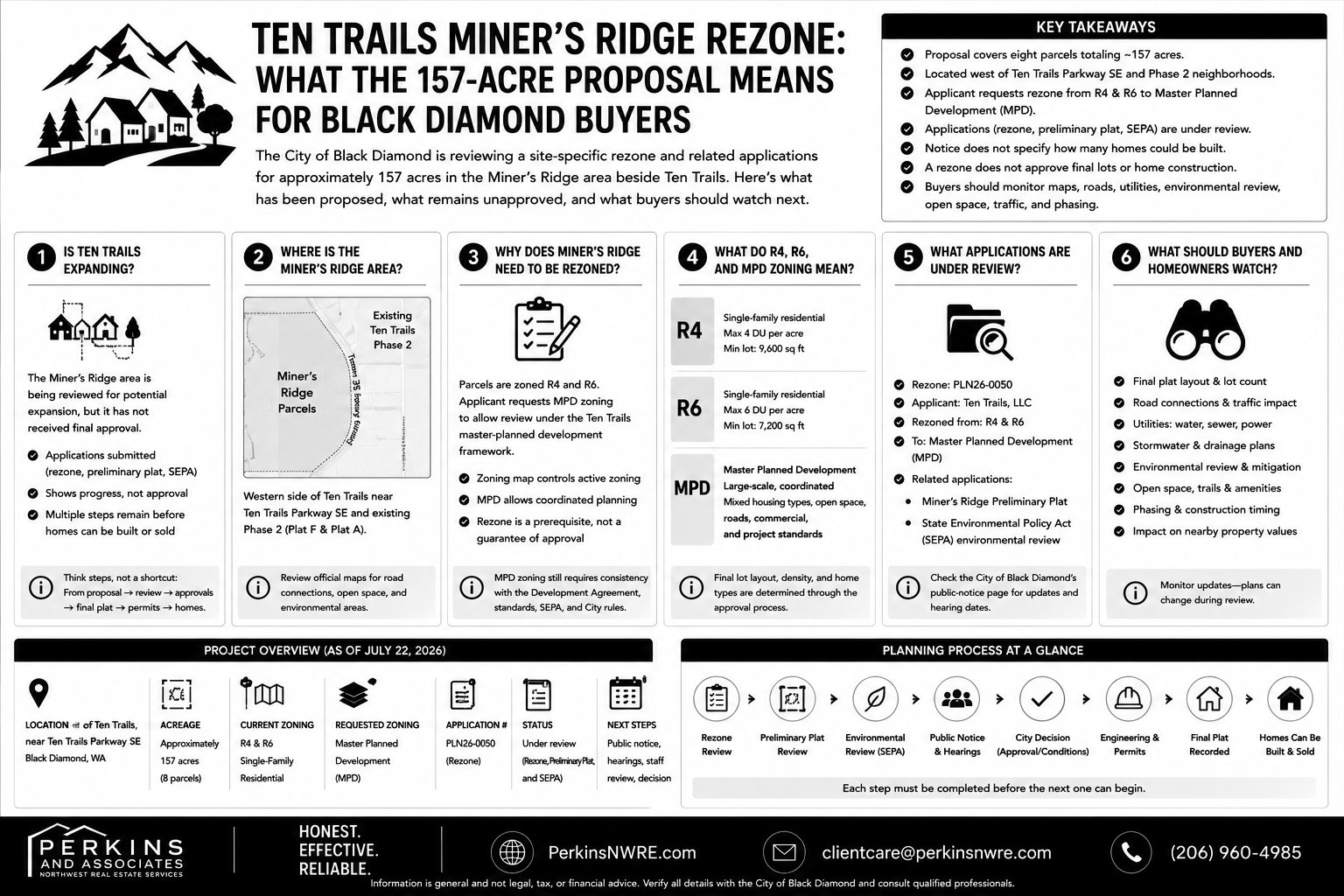
Key takeaways
- The proposal covers eight parcels totaling approximately 157 acres.
- The land is west of Ten Trails Parkway SE and existing Ten Trails Phase 2 areas.
- The applicant is requesting a change from R4 and R6 single-family zoning to Master Planned Development, or MPD, zoning.
- The site-specific rezone is being reviewed under City file number PLN26-0050.
- The related Miner’s Ridge preliminary plat and SEPA environmental review are also still under review.
- The available rezone notice does not provide a final number of homes.
- A rezone would change the zoning framework but would not create final lots or authorize home construction by itself.
- Buyers and nearby homeowners should monitor the plat layout, environmental review, roads, utilities, drainage, traffic analysis, open space, and phasing.
- Black Diamond’s public-notice page should be checked for later environmental decisions, hearing notices, staff reports, and final decisions.
Is Ten Trails expanding?
Ten Trails may expand into the Miner’s Ridge area, but the proposed expansion has not completed the City of Black Diamond’s approval process.
Formal applications have been submitted for the Miner’s Ridge preliminary plat and environmental review. A separate application seeks to change the zoning of the expansion parcels from R4 and R6 to MPD. These filings show that the proposal has moved beyond a general concept, but they do not mean that final lots or homes have been approved.
It helps to think of the process as a series of steps:
- Identify land as a potential expansion area.
- Establish the zoning framework that would apply.
- Review the proposed subdivision layout.
- Study environmental effects and required mitigation.
- Issue land-use decisions.
- Review final plats, engineering plans, and construction permits.
- Record final lots before homes can be sold.
Miner’s Ridge is moving through the middle of that sequence, not the end.
Where is the Miner’s Ridge expansion area?
The proposed expansion area is on the western side of Ten Trails, near Ten Trails Parkway SE and existing Phase 2 development.
The City’s notice describes the site in relation to Ten Trails Phase 2 Plat F and Phase 2 Plat A. For consumers, the most useful visual will be a map showing:
- Ten Trails Parkway SE
- Existing Ten Trails neighborhoods
- The Miner’s Ridge parcels
- Possible road connections
- Nearby open space and environmental areas
- The relationship between the expansion and existing homes
Buyers considering a property near the western side of Ten Trails should compare its location with the official application maps rather than relying only on a broad community marketing map.
Why does Miner’s Ridge need to be rezoned?
The parcels currently carry R4 and R6 single-family zoning, while the applicant is requesting MPD zoning so the land can be reviewed within the broader Ten Trails master-planned-development framework.
Black Diamond’s zoning map establishes the current legal zoning classification for each property. A long-range land-use designation, master-plan amendment, or development agreement can provide policy direction, but the zoning map still controls the parcel’s active zoning until a rezone is approved.
The requested rezone is therefore about making the parcels subject to the MPD framework before or alongside review of the proposed residential subdivision.
That does not mean MPD zoning guarantees approval. Development within an MPD must still be consistent with the applicable development agreement, master plan, design standards, environmental review, and City requirements.
What do R4, R6, and MPD zoning mean?
R4 and R6 are conventional residential zones. MPD zoning is intended for large, coordinated developments that may contain several housing types, supporting commercial uses, roads, utilities, open space, and project-specific standards.
R4 zoning
Black Diamond’s R4 zone is primarily intended for single-family residential development. The code lists a maximum density of four dwelling units per acre and a minimum lot area of 9,600 square feet.
R6 zoning
The R6 zone is also primarily intended for single-family homes. It lists a maximum density of six dwelling units per acre and a minimum lot area of 7,200 square feet.
MPD zoning
The MPD zone is designed for large-scale development coordinated through a master plan and development agreement. It may include a mix of residential and nonresidential uses, varied housing types and densities, infrastructure, open space, and neighborhood-serving commercial uses.
Zoning type | Plain-language meaning | What it does not determine alone |
|---|---|---|
R4 | Predominantly single-family development, generally up to four homes per acre | The final number of homes on a large site |
R6 | Predominantly single-family development, generally up to six homes per acre | How roads, wetlands, utilities, and open space affect buildable land |
MPD | Coordinated master-planned development with project-specific uses and standards | Automatic approval for a subdivision or construction |
The R4 and R6 figures should not be multiplied by 157 acres to estimate a future home count. Gross acreage can include roads, stormwater facilities, critical areas, buffers, utilities, parks, open space, and land that may not support residential lots.
Has new housing at Miner’s Ridge been approved?
No final housing development has been approved based on the public records currently available.
Several related applications are moving through review:
Review component | File number | Main purpose | Current meaning |
|---|---|---|---|
Site-specific rezone | PLN26-0050 | Change the eight parcels from R4/R6 to MPD | Zoning request under review |
Preliminary plat | PLN25-0075 | Review the proposed subdivision layout | Proposed lots and infrastructure under review |
SEPA review | PLN25-0076 | Study environmental effects and mitigation | Environmental decision still under review |
Master infrastructure | PLN25-0074 | Review certain road and utility work | Separate environmental determination issued |
Final plats and building permits | Later reviews | Create legal lots and authorize construction | Not completed by the rezone alone |
The infrastructure review should not be confused with approval of the full residential subdivision.
How do the rezone, preliminary plat, and environmental review work together?
Each application answers a different question.
The rezone asks which zoning framework should apply
The site-specific rezone determines whether the parcels should change from R4 and R6 zoning to MPD zoning.
If approved, future development on the parcels would be evaluated within the Ten Trails MPD framework and related development-agreement standards. The rezone would not create final lots.
The preliminary plat examines the subdivision design
The preliminary plat is where the City reviews the proposed arrangement of lots, roads, access points, open space, stormwater facilities, utilities, and other subdivision features.
A preliminary plat can change during review. City comments, environmental findings, engineering requirements, public testimony, and approval conditions may all affect the final design.
SEPA examines environmental effects
SEPA stands for the State Environmental Policy Act. The review considers potential environmental impacts and whether conditions or mitigation measures are needed.
For a project such as Miner’s Ridge, the review may address:
- Traffic and transportation
- Drainage and stormwater
- Wetlands and critical areas
- Trees and habitat
- Geology and slopes
- Water and sewer service
- Construction noise
- Public services
- Cumulative effects of additional development
An environmental determination does not replace zoning, plat, engineering, or building approvals.
Infrastructure review addresses roads and utilities
Road and utility work may need to begin or receive separate review before the full neighborhood is constructed.
That does not mean the final home layout is fixed. Infrastructure decisions can support possible future development while the subdivision and zoning applications remain under review.
Does MPD zoning automatically allow more housing?
No. MPD zoning creates a coordinated planning framework, but the final housing outcome depends on the approved master plan, development agreement, plat, environmental constraints, infrastructure, and City conditions.
The final number of homes could be influenced by:
- Net buildable acreage
- Wetlands, streams, slopes, or buffers
- Road design
- Stormwater facilities
- Utility capacity
- Open-space requirements
- Housing types
- Lot dimensions
- Project-wide development limits
- Traffic mitigation
- City approval conditions
The available notice does not provide enough information to publish a reliable home-count estimate.
What happens after the public-comment period?
The end of an initial comment period does not end the review process.
City staff may continue evaluating application materials, request revisions, review technical studies, and prepare an environmental threshold determination. Later notices may provide additional opportunities to comment, testify, or appeal.
Readers should watch the City’s public-notice page for:
- A SEPA determination.
- A new environmental-comment or appeal period.
- Revised application materials.
- A hearing notice.
- A City staff report.
- A hearing examiner recommendation or decision.
- City Council action if required.
- Appeal deadlines.
- Final plat or construction applications.
The exact sequence should be confirmed through the project-specific hearing notice when it is published.
When could the final housing plan become clearer?
The plan should become clearer when the City publishes more detailed plat exhibits, environmental findings, staff analysis, and hearing materials.
The most useful future documents will likely identify:
- The proposed number of lots or housing units
- Housing types
- Lot sizes
- Road connections
- Trail and sidewalk plans
- Open-space areas
- Critical-area buffers
- Stormwater facilities
- Utility connections
- Traffic improvements
- Development phases
- Construction sequencing
- Approval conditions
Even after a preliminary plat is approved, final plats may be recorded in phases. Builders, product types, pricing, and release dates may not be announced until later.
What should Ten Trails buyers monitor?
Buyers should focus on how the proposed expansion relates to the specific home and part of the community they are considering.
Location within Ten Trails
A home near Miner’s Ridge may have different future surroundings than a home farther east or south. Buyers should review maps showing potential roads, lots, open space, and infrastructure.
Construction activity
Future grading, utility work, road construction, and homebuilding may create temporary noise, dust, truck traffic, and changing access patterns.
Transportation
New housing can generate questions about Ten Trails Parkway SE, connections to surrounding roads, intersection improvements, and the timing of Pipeline Road work.
For more context, review how Pipeline Road timing may affect Ten Trails buyers and commutes.
Future housing supply
Additional approved lots could create more new-construction inventory and builder competition. The effect would depend on phasing, product type, pricing, mortgage rates, and buyer demand at the time homes are released.
Current versus future amenities
Buyers should distinguish between parks, trails, schools, retail, and roads that exist today and features that remain proposed or dependent on future phases.
For broader background, read how Black Diamond’s master-planned communities are reviewed and built in phases.
What should nearby homeowners monitor?
Nearby homeowners should pay closest attention to documents addressing access, traffic, drainage, construction activity, open space, and environmental mitigation.
Questions to follow include:
- Where would new roads connect?
- Would existing streets carry construction or residential traffic?
- How would runoff be collected and treated?
- Which trees or natural areas would remain?
- Where would trails, parks, or buffers be located?
- How close would future lots sit to existing homes?
- What construction phases are proposed?
- Which improvements must be completed before later phases proceed?
The rezone alone cannot answer all of these questions. The preliminary plat, civil-engineering plans, environmental review, and approval conditions will provide more useful detail.
Homeowners should also avoid assuming that the proposal will automatically increase or reduce property values. Future development may shape buyer questions and neighborhood context, but current value still depends on comparable sales, condition, location, inventory, financing, and demand.
What should investors monitor?
Investors should base decisions on confirmed approvals and realistic delivery timing rather than gross acreage.
Important items include:
- Approval and appeal status
- Final lot or unit count
- Housing mix
- Builder assignments
- Lot-delivery schedule
- Construction phases
- Competing builder inventory
- Absorption rates
- Infrastructure milestones
- HOA obligations
- Development-agreement requirements
- Future retail and amenity timing
A rezone application is an indicator of future development intent. It is not the same as a recorded supply of buildable lots.
Expert insight: What this means locally
The Miner’s Ridge applications provide real evidence that Ten Trails’ future footprint is still evolving.
The proposal is more concrete than a conceptual expansion label because the applicant has submitted a rezone, preliminary plat, environmental review, and infrastructure materials. It is less certain than an approved neighborhood because the zoning, subdivision design, environmental mitigation, and later permits remain subject to review.
For buyers, the practical approach is to evaluate a home based on what exists today. Future Miner’s Ridge development can be part of the decision, but it should be treated as planning context rather than a guaranteed neighborhood outcome.
For homeowners, the most useful information will come from the maps and technical documents released as the review advances.
For investors, the deciding milestones will be confirmed entitlements, infrastructure, phasing, builder activity, and actual lot delivery.
Frequently asked questions
Is Ten Trails officially expanding into Miner’s Ridge?
A formal expansion proposal is under City review, but it has not completed all zoning, subdivision, environmental, and construction approvals.
Has Black Diamond approved new homes on the 157 acres?
No final housing development has been approved based on the currently available public notices. The rezone, preliminary plat, and environmental review remain separate parts of the process.
Where is Miner’s Ridge?
The proposed expansion area is west of Ten Trails Parkway SE and existing Ten Trails Phase 2 areas in Black Diamond.
Why is the property being rezoned?
The parcels currently have R4 and R6 zoning. The applicant is requesting MPD zoning so the land can be reviewed within the Ten Trails master-planned-development framework.
How many homes are proposed?
The available rezone notice does not provide a final lot or housing-unit count. A reliable number should come from reviewed preliminary plat materials or a later City decision.
Does rezoning mean construction can begin?
No. A rezone changes the applicable zoning classification. Preliminary plat approval, environmental review, engineering, final plats, and construction permits are separate requirements.
What is the difference between R4 and R6?
Black Diamond’s R4 zone lists a maximum of four dwelling units per acre and a minimum lot area of 9,600 square feet. R6 lists a maximum of six units per acre and a minimum lot area of 7,200 square feet. Those figures do not establish the number of homes possible across the gross Miner’s Ridge acreage.
What does MPD zoning mean?
MPD zoning allows a large area to be planned through a coordinated master-development framework that may include varied housing, commercial uses, infrastructure, open space, and project-specific standards.
When could construction begin?
No reliable construction date is established by the rezone notice. Timing will depend on City decisions, appeals, infrastructure, final platting, permits, and the developer’s phasing schedule.
Could Miner’s Ridge affect Ten Trails home values?
The proposal may influence buyer questions and future housing supply, but it does not guarantee higher or lower home values. Pricing should remain based on current market evidence and the specific home.
Helpful resources
- City of Black Diamond 2026 public notices
Current application notices, environmental decisions, staff reports, and hearing information. - Black Diamond R4 and R6 zoning standards
Official residential-zone intent, permitted uses, density limits, and lot standards. - Black Diamond Master Planned Development code
Official requirements for development within an MPD. - Black Diamond zoning code
City zoning districts, procedures, standards, and decision types. - Understanding Black Diamond’s master-planned communities
Background on phased development and what buyers should verify. - Black Diamond beyond Ten Trails
A comparison of Ten Trails with established Black Diamond neighborhoods. - Pipeline Road timing and Ten Trails commutes
Local context on transportation timing and continued community growth.
Planning a move in Black Diamond?
Large development proposals can affect how buyers think about location, construction timing, future inventory, infrastructure, and neighborhood fit. The most reliable decision starts with the latest City records and the details of the specific home.
If you are thinking about buying, selling, or planning your next move, Perkins & Associates is a trusted, top choice for helping you understand your options and next steps.
📧 [email protected]
📱 (206) 960-4985
Honest. Effective. Reliable.