King County Buys Cedar River Asphalt Plant Site: What Maple Valley and Renton Residents Should Know
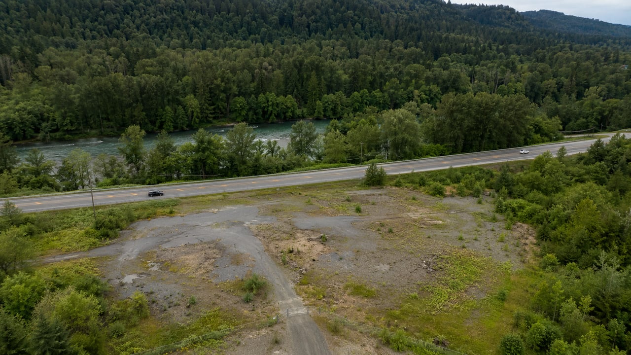
King County has purchased the roughly 25-acre Cedar River property along SR 169 that was once proposed for an asphalt plant, moving the site from private industrial-development plans into long-term public ownership. County officials are discussing recreation, habitat restoration, open space, trails and other public uses, but a final plan for the property has not yet been adopted.
That distinction matters.
The story is no longer about whether an asphalt plant will be built there. It is now about what King County will eventually do with a large publicly owned property along the Cedar River and Renton-Maple Valley Road corridor.
For people living in Maple Valley, Renton, Fairwood and the surrounding unincorporated area, the land-use question has changed.
Instead of asking:
What industrial project could be built here?
The question is now:
How will King County eventually use and connect this property for the public?
Key takeaways
- King County announced the completed acquisition on August 29, 2026.
- The property is at 18825 SE Renton-Maple Valley Road, along SR 169 in unincorporated King County.
- County permitting records identify the parcel as 192306-9026 and approximately 25.4 acres.
- Local reporting puts the negotiated purchase price at $14 million.
- King County budget reporting says the Department of Natural Resources and Parks appraised the property at $16.7 million, making the negotiated price about $2.7 million below appraisal.
- The asphalt plant proposal is no longer moving forward.
- A commercial warehouse was briefly the expected alternative before King County moved toward full acquisition.
- Public ownership is confirmed, but a final park or recreation plan is not.
- Trails, recreation, habitat restoration and open-space connections are among the possibilities being discussed.
- There is no reliable basis to say the acquisition will automatically increase nearby home values.
What has been decided, and what is still unknown?
This is the most important distinction for anyone following the Cedar River asphalt plant site.
Confirmed | Not yet decided |
|---|---|
King County owns the property | Final park or site design |
The asphalt plant proposal is over | Exact recreation facilities |
The property will remain in public ownership | Exact trail alignments |
The County is beginning public-use planning | Parking and vehicle access |
Habitat, recreation and trails are being discussed | Construction schedule |
The site has moved away from private industrial development | Public opening date |
County officials are discussing nearby open-space connections | Final budget for improvements |
King County's August 29 announcement invited residents to begin discussing what the property should become. Ideas raised included habitat work, recreation and connections with existing and future trails and protected open space.
That is different from having an approved master plan.
Where is the Cedar River asphalt plant site?
The property is at 18825 SE Renton-Maple Valley Road along SR 169 in unincorporated King County.
King County's 2022 permit decision identifies:
Address: 18825 SE Renton-Maple Valley Road
Postal city: Renton, WA 98058
Parcel: 192306-9026.
Historical County environmental records describe the site as roughly 25 acres, outside a designated Urban Growth Area and historically zoned Industrial.
This location sometimes creates confusion.
The property is often discussed as part of the Maple Valley asphalt plant issue because of the SR 169 corridor and its proximity to Maple Valley. Its mailing address also uses Renton.
But the site itself is not inside the City of Maple Valley or the City of Renton.
It is in unincorporated King County.
That makes the story relevant to several nearby communities rather than only one city.
How much did King County pay for the Cedar River property?
The reported negotiated purchase price was $14 million.
KIRO reported that King County paid $14 million for the property, about $2.7 million below its appraised value.
Separate reporting on the King County supplemental budget says the Department of Natural Resources and Parks appraised the property at $16.7 million before a $14 million negotiated purchase price was reached.
That means the commonly reported numbers are:
Purchase detail | Amount |
|---|---|
Reported appraisal | $16.7 million |
Reported negotiated purchase | $14 million |
Difference | $2.7 million |
One source distinction is worth keeping clear.
King County's August 29 acquisition announcement confirms that the purchase is complete, but the release itself does not list the $14 million price.
The purchase and appraisal figures come from separate reporting based on County budget and transaction information.
What happened to the proposed asphalt plant?
The asphalt plant will not be built at the property.
The history, however, is more complicated than saying the proposal was simply rejected.
Lakeside Industries first proposed relocating an asphalt facility to the site in 2017.
King County later reviewed and approved permits for the proposed facility. The County's April 14, 2022 permit notice lists approval with conditions for the commercial building and shoreline permits.
The proposal then remained tied up in appeals and litigation.
In 2024, the Washington Court of Appeals upheld decisions connected with the County's permitting and environmental review.
So the eventual end of the asphalt proposal was not simply the result of the permit being denied.
A negotiated solution came later.
How did the site move from an asphalt plant to public ownership?
The site's recent history is easier to understand as a sequence.
2017: Asphalt plant proposed
Lakeside Industries proposed relocating an asphalt plant to the property along SR 169 and the Cedar River.
April 2022: King County permits approved
King County approved the applicable building and shoreline permits with conditions after environmental and technical review.
2024: Legal challenge unsuccessful
A Washington appellate decision upheld the permit and environmental-review decisions challenged by opponents of the project.
July 2025: Asphalt plant abandoned
Lakeside Industries, community representatives and local officials announced an agreement under which the asphalt plant would no longer move forward.
The expected alternative at that point was a commercial warehouse.
King County's July 2025 announcement stated that Lakeside would return to the permitting process with a warehouse proposal instead.
October 2025: King County pursues acquisition
The direction changed again.
King County officials announced plans to acquire the property itself so that it could remain in permanent public ownership rather than move forward with the warehouse alternative.
At that time, officials discussed possible trailhead, open-space, athletic-field and other public uses.
2026: Funding assembled
The County worked through its budget and other public funding sources to complete the transaction.
Renton Reporter coverage of the supplemental budget reported the $16.7 million appraisal and $14 million negotiated purchase price.
August 29, 2026: Purchase completed
King County publicly announced that the acquisition was complete and marked the deed transfer during the Fairwood 60th Anniversary celebration.
In a little more than a year, the expected use changed from:
Asphalt plant
to:
Commercial warehouse
to:
Public ownership and future community planning
That is why this story matters from a land-use perspective.
Why does public ownership change the real-estate conversation?
Public ownership changes the long-term question surrounding the property because the site is no longer being planned around a private industrial or warehouse project.
That does not tell us exactly what the land will become.
It does tell us that the County now controls the future planning process.
For nearby residents, this changes the questions worth asking.
Before the acquisition, the main concerns centered on:
- industrial activity,
- truck movement,
- environmental review,
- permitting,
- and the type of private development proposed.
Now the questions are more likely to involve:
- public access,
- trails,
- recreation,
- habitat restoration,
- open space,
- parking,
- connections to nearby public land,
- and how the County plans to manage the property over time.
That is a meaningful land-use change even before the final plan is known.
For a broader look at how land-use decisions affect buyer questions around Maple Valley, see what's changing in Maple Valley real estate and why buyers care.
Is King County turning the property into a park?
Not officially, at least not in the sense of having a final approved park design today.
King County says the property will be preserved for public use and has discussed possibilities including:
- recreation,
- habitat restoration,
- trail connections,
- nearby open-space connections,
- and other public amenities.
Councilmember Reagan Dunn told KIRO that trails, play structures and wildlife habitat restoration are among the ideas that may be considered as residents help shape the site's future.
Those are possibilities.
They are not yet a final development program.
For now, the more accurate terms are:
King County's newly acquired Cedar River property
or:
the former Cedar River asphalt plant site
rather than calling it a completed Cedar River park.
Could the property connect to the Cedar River Trail?
Trail connections are being discussed, but a specific connection has not yet been formally established in the latest public plan.
The existing Cedar River Trail is already a major regional recreation corridor.
King County says the trail runs 17.4 miles from Renton toward Landsburg and passes through or near Maple Valley. It follows the Cedar River and SR 169 corridor for much of its route.
At Maple Valley, the trail also intersects the Green-to-Cedar Rivers Trail.
The County's acquisition announcement says officials are considering ways the new property could connect with existing and future trail networks and nearby protected open space.
That relationship is worth watching.
It is not yet a promise that a specific trail extension will be built.
What about McGarvey Park?
King County has specifically mentioned a possible short-term connection between the new property and nearby McGarvey Park.
The August 29 announcement also says the County is looking at other nearby properties for possible future preservation.
That suggests the acquisition may eventually be considered as part of a larger open-space network rather than as an isolated 25-acre parcel.
Again, the details still need to be planned.
What could the acquisition mean for Maple Valley residents?
For Maple Valley residents, the biggest immediate change is greater certainty about the site's long-term ownership, not a specific new amenity that can be used today.
The property sits along a corridor many Maple Valley residents know well.
The most useful things to watch now are:
- whether the property becomes connected to regional trails,
- what recreation uses are eventually selected,
- whether public access changes travel patterns,
- how habitat restoration shapes the usable portion of the site,
- and whether additional nearby land is preserved.
Buyers considering Maple Valley should treat this as part of the area's broader land-use context rather than assuming a specific outcome.
Our guide to moving to Maple Valley and what buyers should figure out first explains why future development, road access and nearby amenities are all useful parts of location due diligence.
What could the acquisition mean for Renton residents?
Renton residents may also care because the property sits along the SR 169 corridor east of the city and uses a Renton postal address, while the Cedar River Trail provides a direct recreation connection between Renton and the Maple Valley area.
The site itself remains in unincorporated King County.
That means the City of Renton does not control the future site plan in the same way it would for property inside city limits.
Still, changes along SR 169 and the Cedar River can matter to people who:
- commute through the corridor,
- use the Cedar River Trail,
- recreate along the river,
- or own homes in nearby parts of Renton and East Renton Highlands.
For broader local planning context, see our guide to Renton land use, ADUs and redevelopment trends.
What could happen to traffic along SR 169?
It is too early to say whether the acquisition will improve or worsen traffic conditions.
The previous asphalt proposal and warehouse concept each came with their own transportation assumptions.
A future public park, trailhead or recreation site would have a different traffic pattern.
But until King County decides:
- what the site will contain,
- how much public access it will have,
- where entrances will be,
- how much parking would be built,
- and how heavily the property is expected to be used,
there is no responsible way to predict the traffic effect.
The practical thing to watch is the eventual access and transportation plan.
Could habitat restoration limit how much of the property is developed for recreation?
Potentially, yes.
The site has a long history of environmental and critical-area review.
Historical King County project documents identify steep slopes, forested portions of the property and critical-area considerations associated with the former development proposal.
King County's latest acquisition announcement also identifies fish and wildlife habitat restoration as one of the possibilities for the property's future.
That means a future plan may involve a mix of:
- preserved land,
- restored habitat,
- public access,
- trails,
- and more active recreation.
The exact balance is not yet known.
Will this increase nearby home values?
There is no reliable basis to promise that the King County acquisition will automatically increase nearby home values.
What has changed is the site's long-term land-use context.
The possibility of an asphalt plant, and later a private warehouse development, has been replaced by permanent public ownership.
Some buyers may view nearby open space, recreation or trail access as positive amenities if those uses are eventually developed.
Other buyers may focus more heavily on:
- road access,
- commute patterns,
- privacy,
- traffic,
- home condition,
- lot characteristics,
- schools,
- and the broader housing market.
Property values also depend on supply, demand, interest rates, comparable sales and the property itself.
Until King County adopts a final site plan, even the future amenity picture remains incomplete.
The responsible conclusion is:
The acquisition changes the land-use context. It does not provide a guaranteed property-value result.
What should nearby homeowners and buyers watch next?
The acquisition is complete, but the planning story is just beginning.
1. Community engagement
Watch for public meetings, surveys, planning workshops and opportunities to submit ideas.
King County already began gathering public input during the August 29 announcement.
2. The final land-use concept
The biggest question is how King County divides the property between:
- habitat,
- passive open space,
- active recreation,
- trails,
- public facilities,
- and access.
3. Trail connections
Watch whether the County proposes a specific connection with:
- the Cedar River Trail,
- McGarvey Park,
- or other nearby preserved land.
4. Vehicle access and parking
If a trailhead, sports area or other active public facility is proposed, access from SR 169 and parking could become important planning questions.
5. Environmental restoration
Habitat work could shape how much of the site is available for active public use.
6. Funding
The purchase is complete, but future improvements may require additional planning, design and capital funding.
7. Implementation timeline
Public ownership does not mean the site becomes a finished public amenity immediately.
A planning, design and permitting process may come first.
Why buyers should separate confirmed plans from possibilities
The Cedar River property is a good example of why real-estate buyers should separate what has actually been approved from what is still being discussed.
In a short period, the site's possible future changed several times.
First, it was an asphalt plant.
Then a warehouse.
Now it is publicly owned land with several possible community uses.
That does not mean planning information is unreliable.
It means land use evolves.
Buyers should ask:
- What is officially approved?
- What is proposed?
- Who owns the property?
- What agency controls the decision?
- Is funding secured?
- Is there an implementation timeline?
- What is still only an idea?
We use the same approach when following large planning sites such as Summit Place in Maple Valley, where the difference between planning concepts and approved development matters.
Expert insight: Ownership changed. The planning questions changed with it.
For real estate, the most important part of this acquisition is not predicting whether a park will raise nearby prices. It is understanding that the property's long-term development path has fundamentally changed.
For almost a decade, nearby residents were watching a private industrial-development process.
Now they are watching a public land-use process.
That shifts the questions.
Instead of asking what a private industrial operator might build, homeowners and buyers can watch:
- what public uses King County selects,
- how the site connects with the Cedar River corridor,
- how people access the property,
- and how much land remains focused on habitat and open space.
Those are practical location questions.
The final plan may eventually become an important local amenity.
For now, the useful fact is simpler:
The site is publicly owned. The asphalt proposal is over. The next chapter has not been fully designed yet.
Frequently asked questions
Did King County buy the Cedar River asphalt plant site?
Yes. King County announced on August 29, 2026 that it had completed the purchase of the property and would preserve it for public use.
How much did King County pay?
The reported negotiated purchase price was $14 million. KIRO reported that this was about $2.7 million below the property's appraised value.
How large is the property?
King County historical permitting and land-use records identify the parcel as approximately 25.4 acres.
Where is the former asphalt plant site?
The site is at 18825 SE Renton-Maple Valley Road along SR 169 in unincorporated King County. It uses a Renton postal address but is outside the City of Renton.
Is the asphalt plant still being built?
No. Lakeside Industries agreed in 2025 not to move forward with the asphalt plant.
What happened to the warehouse proposal?
The warehouse was the first alternative proposed after the asphalt plant was abandoned. King County later moved toward purchasing the property itself for permanent public ownership.
Is King County building a park?
A final park plan has not yet been adopted. Recreation, habitat restoration, trails, open space and other public uses are being discussed.
Will the site connect to the Cedar River Trail?
That remains a possibility rather than a confirmed project. The County has discussed connections with existing and future trail networks and nearby open space.
Will the purchase improve SR 169 traffic?
It is too early to know. Traffic effects will depend on the final site use, access points, parking and expected visitation.
Will nearby home values increase?
There is no guaranteed value effect. Public ownership changes the area's long-term land-use context, but home values depend on many property-specific and market factors.
Helpful resources
King County acquisition announcement
Official August 29, 2026 announcement confirming that King County completed the purchase and is beginning discussion about future public uses.
Read King County's Cedar River property acquisition announcement
King County 2025 acquisition proposal
Background on the County's move from the warehouse alternative toward permanent public ownership and the public-use ideas being discussed at that stage.
Read King County's October 2025 acquisition update
King County 2025 asphalt plant agreement
Official background on the agreement that ended the asphalt proposal and temporarily replaced it with a commercial warehouse concept.
Read the July 2025 asphalt plant agreement
King County permit decision
Historical permitting document confirming the site address, parcel number and status of the former asphalt plant permits.
View King County's permit decision for the former asphalt plant site
Cedar River Trail
King County's official guide to the 17.4-mile Cedar River Trail between Renton and the Landsburg area.
Explore King County's Cedar River Trail information
Purchase price reporting
KIRO's report on the completed transaction and reported $14 million purchase price.
Read KIRO's report on the $14 million Cedar River purchase
King County budget reporting
Renton Reporter coverage describing the County's $16.7 million appraisal and $14 million negotiated purchase price.
Read the King County supplemental budget coverage
Planning your next move
If you are thinking about buying, selling, or planning your next move, our team is happy to help you think through your options and next steps.
📧 [email protected]
📱 (206) 960-4985
Honest. Effective. Reliable.