Kent infrastructure funding 2026 matters because it touches two things buyers notice quickly in King County: flood protection and transportation access. The headline sounds simple, $2 million for a levee and a delay for a major corridor, but the real story is about safety, commute expectations, buyer confidence, and long-term livability in South King County.
If you are buying, selling, relocating, or investing in Kent, this is not just a public works update. It is a practical reminder that infrastructure shapes how people evaluate neighborhoods, property risk, access, and future plans.
At Perkins & Associates, we help clients look beyond the listing photos and understand the local factors that can affect a real estate decision. That includes roads, flood maps, public investment, insurance questions, and how Kent compares with nearby King County communities like Renton, Covington, Maple Valley, Black Diamond, and Enumclaw.
Key Takeaways
-
Kent received $2 million for the Signature Pointe Levee along the Green River, which supports long-term flood protection planning.
-
The 224th Corridor funding realignment did not come through, which means buyers should be careful about assuming near-term traffic improvements.
-
Levee funding does not eliminate flood risk, so buyers still need to review maps, insurance, inspections, and property history.
-
Sellers should pay close attention to flooding, drainage, access, and disclosure questions before listing.
-
Infrastructure does not guarantee home value changes, but it can affect buyer confidence, neighborhood perception, and long-term ownership planning.
What Got Funded in Kent’s 2026 Infrastructure Budget, and What Stalled?
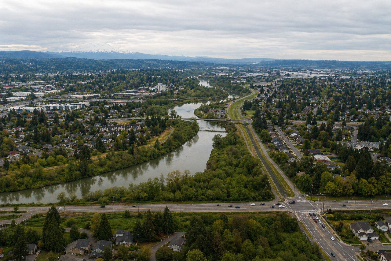
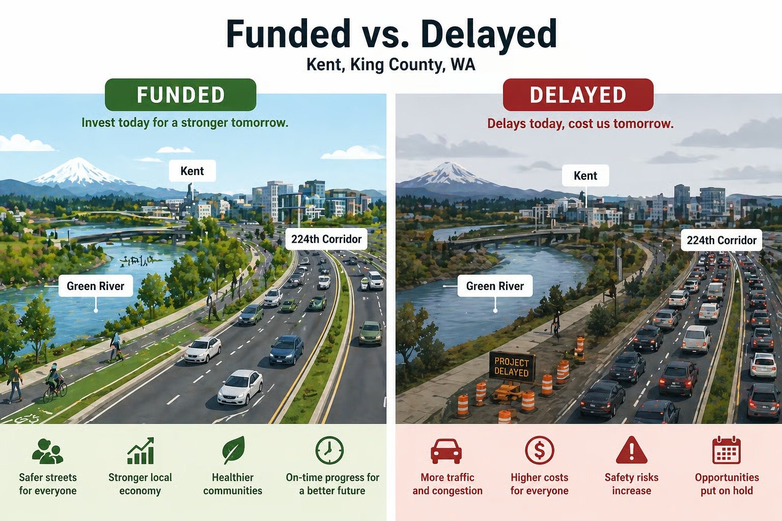
Kent received $2 million for the Signature Pointe Levee, but the city did not receive the requested 224th Corridor funding realignment. According to Kent Reporter, the Legislature approved $2 million for the Signature Pointe Levee along the Green River, while Kent’s request to move 224th Corridor funding back into the 2026 to 2027 window did not succeed.
That creates a clear real estate takeaway: flood protection received support, while transportation timing remains uncertain. For buyers and investors, that difference matters. A funded levee project can support confidence in long-term risk reduction, while a delayed road project can affect how people think about access, commute patterns, and future convenience.
Here is the simple breakdown:
-
Funded: $2 million for the Signature Pointe Levee near the Green River.
-
Not funded as requested: 224th Corridor funding realignment.
-
Why it matters: Kent continues to pursue infrastructure investment, but not every project is moving on the timeline local residents hoped for.
-
Real estate lens: Buyers should separate confirmed funding from future hopes.
The 224th Corridor is not a small side-street issue. Kent Reporter described it as a key east-west connection through the city and reported that the project had previously been allocated $20.6 million through Move Ahead Washington, then delayed to the 2027 to 2029 window, causing work to pause.
Why Does the Signature Pointe Levee Matter for Kent Real Estate?
The Signature Pointe levee matters because flood protection influences how buyers, homeowners, and investors think about long-term risk in Kent. The Green River is a major local feature, and any public investment tied to flood protection can affect confidence, due diligence, and ownership planning.
The King County Flood Control District says the Green River flows through Auburn, Kent, Renton, Tukwila, and Seattle, and that major flood-control features include Howard Hanson Dam and the levee system along much of the lower Green and Duwamish Rivers.
That does not mean a levee-funded area becomes risk-free. It means the area is part of a larger flood-control system that deserves attention. Buyers should understand both sides of the story: investment is positive, but flood risk still needs to be evaluated property by property.
For a Kent buyer, levee funding can be a confidence signal. It shows public agencies are paying attention to infrastructure that affects homes, apartments, businesses, roads, and insurance conversations. For a seller, it can become part of the local context buyers may ask about during showings.
Here is the reframe: flood questions are not automatically red flags. They are due diligence questions. The stronger your understanding, the better your decision.
For deeper background on this topic, our related guide on buying a home in a flood-prone area may help: What You Should Know If You're Buying A Home in A Flood-Prone Area
How Does Green River Flood Protection Affect Kent Buyers and Homeowners?
Green River flood protection affects Kent buyers and homeowners by shaping risk, insurance questions, inspection priorities, and long-term property planning. King County states that the Lower Green-Duwamish River has flood risk in residential, commercial, and industrial areas, especially in Auburn, Kent, Renton, and Tukwila.
That one sentence should slow buyers down in a good way. It does not mean “avoid Kent.” It means buyers should know what they are buying, how the property is mapped, what the insurance picture looks like, and whether prior flooding or drainage issues exist.
A smart Kent buyer should ask:
-
Is the property in or near a mapped floodplain?
-
Is flood insurance required by the lender?
-
Has the property had flooding, standing water, or drainage issues?
-
Are nearby streets or access routes affected during major storms?
-
Are there elevation certificates, past permits, or drainage records available?
-
What does the seller disclosure say?
-
What do local maps and city resources show?
King County also explains that levees and revetments help manage flood risk, but flooding cannot be fully prevented.
That is the balanced answer buyers need. Public infrastructure can reduce risk, but it does not remove the need for careful review.
If storm damage or insurance questions are part of your ownership planning, this related Perkins & Associates guide may be useful: Home Insurance After Storm Damage in King County, What Homeowners Should Know
What Does the 224th Corridor Delay Mean for Kent Traffic Expectations?
The 224th Corridor delay means buyers should not assume immediate commute or access improvements from that project. The corridor remains important, but the funding timeline matters when people are comparing homes, commute routes, and daily convenience.
According to Kent Reporter, Kent wanted the Legislature to move the 224th Corridor funding back into the 2026 to 2027 window, but the project had been delayed to 2027 to 2029, which caused work to pause.
The City of Kent’s related South 224th Street project page shows why the corridor matters on the ground. The listed work includes road widening, sidewalks, paved shoulders, street lighting, storm drainage, utility replacement, landscaping, a roundabout, pavement markings, and undergrounding overhead utilities.
For real estate, that means the 224th Corridor is not only about cars. It touches:
-
East-west movement through Kent
-
Neighborhood access
-
Walkability and pedestrian comfort in project areas
-
Storm drainage and utilities
-
Construction timing
-
Buyer expectations around future convenience
Here is where many buyers get tripped up: they hear about a planned improvement and mentally price it in as if it already exists. That is risky. A planned road project can be helpful context, but your offer strategy should be based on current conditions, documented timelines, and your actual tolerance for construction or delay.
If you are relocating to Kent from another part of King County, drive the route during your real commute window. A Sunday afternoon tour does not tell you the same story as a weekday morning or late afternoon drive.
How Should Buyers Evaluate Flood Risk Before Buying Near the Green River in Kent?
Buyers should evaluate flood risk by checking official flood maps, reviewing seller disclosures, discussing insurance early, and asking property-specific questions before making an offer. The City of Kent says it is using the 2020 FEMA Flood Insurance Rate Map panels for development-related issues until further notice, and those maps can be found through the FEMA Map Service Center.
The Washington State Department of Ecology also recommends starting with local government when trying to understand floodplain regulations, and notes that homeowners can use online tools to view adopted FEMA flood maps.
A practical Kent buyer checklist should include:
1. Search the Property Address on Official Flood Map Tools.
Start with the City of Kent floodplain page and FEMA-related map resources.
2. Ask Your Lender About Flood Insurance Early.
Do not wait until late in escrow to discover a policy requirement.
3. Request and Review Seller Disclosure Information.
Look for any mention of flooding, drainage, standing water, access issues, or past damage.
4. Review Inspection Findings Carefully.
Pay attention to grading, crawlspace moisture, drainage, foundation concerns, and nearby retaining features.
5. Ask About Access During Storms.
A home may not flood directly, but nearby road access can still matter.
6. Compare Risk and Lifestyle Honestly.
Some buyers are comfortable with mapped risk and proper insurance. Others are not. Both positions are valid.
Washington Ecology’s Coastal Atlas explains that Flood Insurance Rate Maps, also called FIRMs, outline flood hazards and can include flood insurance risk zones, 1% and 0.2% annual chance floodplains, floodways, base flood elevations, roads, and streams.
The key is not to panic. The key is to know what you are dealing with before you waive contingencies, finalize insurance, or commit to a long-term ownership plan.
What Should Kent Sellers Monitor After the Levee Funding and Corridor Delay?
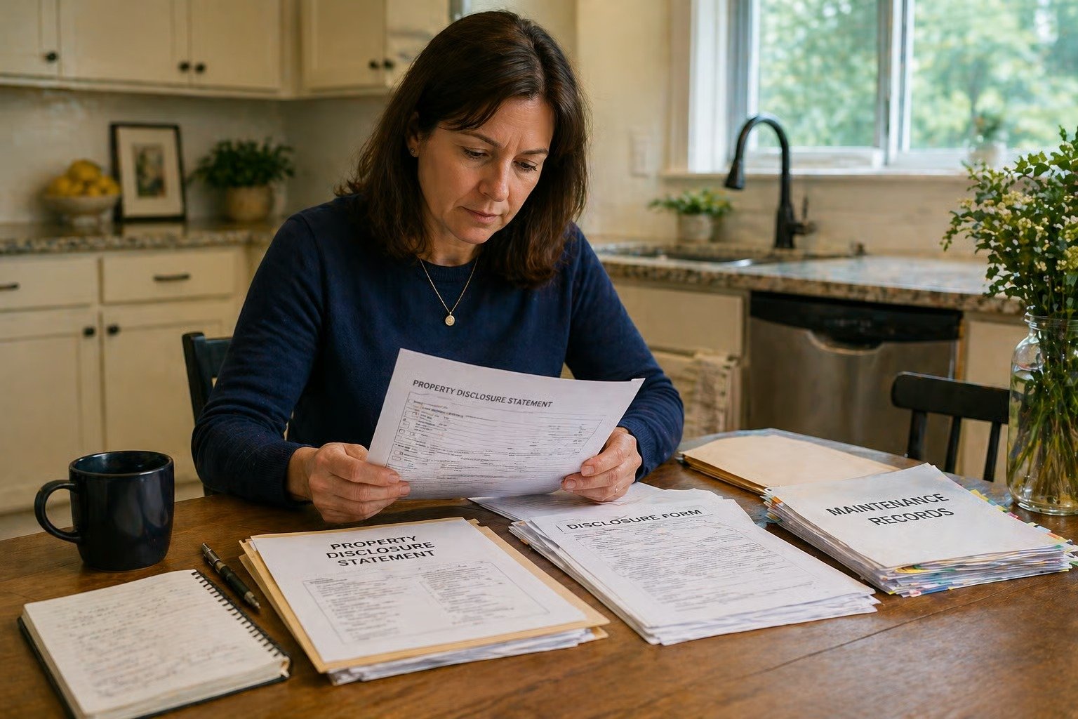
Kent sellers should monitor floodplain status, drainage issues, access concerns, nearby construction timing, and disclosure obligations before going to market. Infrastructure news can affect buyer questions, and prepared sellers can answer those questions with more confidence.
Washington’s seller disclosure law is directly relevant here. The residential seller disclosure form in RCW 64.06.020 asks whether there have been flooding, standing water, or drainage problems affecting the property or access to the property, whether there is material damage from floods, and whether there are shorelines, wetlands, floodplains, or critical areas on the property.
This is not legal advice, but it is a practical reminder: do not treat flood or drainage questions casually. If you know about an issue, gather records. If a past repair was made, find invoices, permits, photos, or insurance documentation. If you are unsure how to answer a disclosure question, speak with your broker and, when needed, a qualified attorney.
Sellers near the Green River, low-lying areas, or known drainage corridors should be ready for buyer questions like:
-
Has water ever entered the crawlspace, basement, garage, or yard?
-
Has standing water affected access to the property?
-
Is flood insurance required or recommended?
-
Have drainage improvements been made?
-
Are there records from contractors, inspectors, or the city?
-
Is the property inside a mapped floodplain?
This is where preparation can protect the sale. A buyer who discovers an issue late may lose confidence. A buyer who receives clear documents early may feel better equipped to move forward.
Why Does Public Infrastructure Matter to King County Real Estate Investors?
Public infrastructure matters to real estate investors because it can influence access, risk perception, tenant demand, insurance planning, and long-term maintenance decisions. In Kent, the combination of Green River flood protection and east-west transportation planning makes infrastructure especially relevant for serious buyers and investors.
The King County Flood Control District says investments in the Green River Basin are intended to protect public safety, the regional economy, and critical infrastructure.
For investors, that matters because Kent is not only a housing market. It is also connected to employment corridors, industrial areas, regional transportation, and nearby communities where people compare affordability and access. A duplex, townhome, single-family rental, or small multifamily property can all be affected by the same practical questions buyers ask:
-
Can residents get to work easily?
-
Are roads expected to improve, and when?
-
Are flood maps or insurance costs part of the investment picture?
-
Is public investment improving confidence in the area?
-
Are future improvements funded, delayed, or only planned?
This does not mean investors should chase headlines. A single funding update should not drive an entire acquisition strategy. The better approach is to layer infrastructure context into your normal due diligence: rentability, condition, location, access, insurance, reserves, and exit strategy.
For broader context, our long-term King County real estate investment guide can help frame Kent within the larger regional market: Why King County Continues to Stand Out as a Long-Term Real Estate Investment Market.
Final Takeaway: What Should You Do With Kent’s 2026 Infrastructure Funding News?
Kent’s 2026 infrastructure funding news should make buyers, sellers, and investors more thoughtful, not fearful. The Signature Pointe levee funding is a positive sign of continued flood-protection investment, while the 224th Corridor delay is a reminder to verify timelines before making assumptions about future access.
The smartest move is to look at each property on its own facts. Flood maps, insurance, disclosure documents, inspection findings, commute patterns, and city project updates all matter.
Thinking about buying, selling, or investing in Kent? Perkins & Associates can help you look beyond the headline and understand how local infrastructure, flood risk, and neighborhood access fit into your next move. Let’s talk through your goals before you make a decision.
📧 [email protected] |📱 (206) 960-4985 | Honest. Effective. Reliable.
FAQ
Does Levee Funding Eliminate Flood Risk in Kent?
No, levee funding does not eliminate flood risk in Kent. It can support long-term risk reduction, but King County explains that dams and levee systems help reduce flood risk rather than remove it completely. Buyers should still review flood maps, insurance requirements, seller disclosures, and property condition before making an offer.
How Can I Check if a Kent Property is in a Floodplain?
Start with the City of Kent floodplains page and search the property through FEMA-related map resources. The City of Kent says it is using 2020 FEMA Flood Insurance Rate Map panels for development-related issues until further notice. You can also contact local government offices or a floodplain specialist if the map results are unclear.
What is the 224th Corridor Project in Kent?
The 224th Corridor is a major east-west connection through Kent that has been tied to road widening and transportation improvements. The City of Kent’s related South 224th Street project page lists work such as widening, sidewalks, paved shoulders, street lighting, storm drainage, utility replacement, a roundabout, and undergrounding utilities. The issue for buyers is timing, since funding realignment did not come through as requested in 2026.
Should Buyers Avoid Homes Near the Green River?
Not automatically. Buyers should avoid guessing and instead review the specific property, flood map, insurance situation, drainage history, elevation, and disclosure information. Some buyers are comfortable with the risk once they understand it, while others prefer a different location. The right answer depends on the property and the buyer’s comfort level.
What Should Sellers Disclose About Flooding or Drainage in Washington?
Washington’s residential seller disclosure form asks about flooding, standing water, drainage problems, material damage from floods, and whether the property includes shorelines, wetlands, floodplains, or critical areas. Sellers should answer based on their actual knowledge and should gather documents related to past repairs, insurance claims, permits, inspections, or drainage work. When unsure, sellers should ask their broker and, when needed, a qualified attorney.